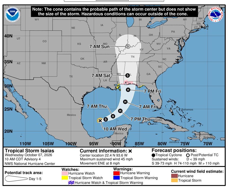
We know our guests, homeowners and all St. George Island lovers are concerned about the effects Tropical Storm Isaias may have on our beautiful Island, so we created this page to keep you updated with the most recent information available to us. For accurate information, (aka no drama), we rely on the National Hurricane Center’s advisories which are issued every six hours: 5:00 am, 11:00 am, 5:00 pm, 11:00 pm – all times EASTERN STANDARD. The NHC also provides intermediate updates at 8:00 am, 2:00 pm, 8:00 pm, 2:00 am.
We depend on our Franklin County Emergency Management (“FCEM”) for local information including evacuations, road and bridge closures, etc. You can also sign up for “Alert Franklin” to receive recorded calls and texts about current conditions.
We encourage our in-house and incoming guests to review our rental policy FAQ’s.
10/10/2026 – 10:45 am EST Update
Hi All! Quick update: The mandatory evacuation issued by Franklin County Florida Emergency Management has officially been lifted and as promised, we have four teams out in the field assessing homes. Those of us in the office are calling guests as the teams report back about the status of each house. *Please note* Most of the pools are a mess from all the wind and we are letting the local pool vendors know. We’re not sure how long it will take them to get to each home – just an fyi. We appreciate everyone for your patience and understanding. – Candace and Dana
10/9/2026 – 5:00 pm EST Update
The 5:00 pm EST NHC advisory states that conditions are deteriorating, especially around Pensacola. St. George Island is experiencing high surf, high winds, rain and flooding in some of the low-lying areas on the Bay side. The storm remains a category 3 and is registering winds at 115 mph. It’s 90 miles south of Pensacola and we ask that you please pray for our friends to the west who are in the direct path as well as all of us experiencing the effects of Isaias.
Per the advisory: “Hurricane-force winds extend outward up to 35 miles (55 km) from the center and tropical-storm-force winds extend outward up to 205 miles (335 km). A sustained wind of 46 mph (74 km/h) with a gust to 58 mph (93 km/h) was recently measured at Fair Point Light 2 near Gulf Breeze, Florida. A wind gust to 56 mph (90 km/h) was reported at the Pensacola Naval Air Station.”
Franklin County remains under a tropical storm warning and we have received a couple of tornado warnings since the 2:00 pm EST update. As of 5:45 pm, the St. George Island bridge is closed due to high winds and we will let you know when it re-opens as soon as possible.
We appreciate you and your well wishes.
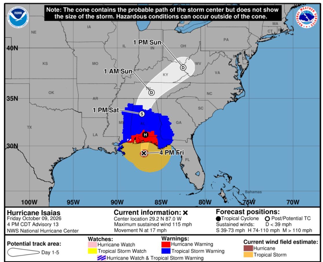
10/9/2026 – 2:00 pm EST Update
The 2:00 pm NHC advisory was published and Hurricane Isaias is now a Category 3 storm and 145 miles south of Pensacola. Both the Franklin County Emergency Management Department and other local and state authorities are speculating that it will make landfall in Pensacola.
As of this advisory, tropical storm force winds extend 205 miles from the center of the storm and St. George Island is approximately 215 miles from Pensacola which we pray means that we are outside any exposure. With that said, it is windy, rainy and very gloomy here now.
If you would like stay abreast of wind speeds, please visit Weather Stem – St. George Island Bridge. https://franklin.weatherstem.com/sgibridge
The emergency management department and other local authorities have always been fantastic about inspecting the Island quickly after a storm and we plan to have all hands on deck first thing tomorrow morning to begin assessments and to un-prep our homes. Check back here regularly, or follow along on social media.
Dana has been a property manager on St. George Island since 1991 and I was responsible for crisis management at Resort Vacation Properties for 12 years. We have a lot of experience with storms and the safety our guests and homeowners is our priority.
If you have any questions or need assistance, please do not hesitate to reach out: Candace’s cell number is (850) 728-0601 and Dana can be reached at (850) 370-6108.
Please pray for everyone’s safety and for minimal, if any damage to our beloved island.
10/9/2026 – 5:00 am EST Update
This morning’s update from the NHC still shows Isaias arriving late tonight/early Saturday morning somewhere between Ocean Springs, MS and the Bay/Gulf County line. We fully expect St. George Island to be rainy and windy today, but we are business as usual for guests due to arrive tomorrow afternoon and Sunday. Our team will be in the field first thing Saturday morning doing assessments, and housekeepers and inspectors will prepare our homes as if it is a regular Saturday. We do not expect there to be widespread damage to our homes or the Island in general, our biggest concern is the storm surge on the Bay side of the Island. The water should recede during low tide which is approximately 9:32 am tomorrow morning. There will most likely be standing water in certain areas, but due to the trajectory of this storm, we believe the roads will be passable by tomorrow afternoon. If there is damage to a vacation home that makes it uninhabitable, or the roads are impassable, we will call the affected guests as soon as we discover the issues.
We have read a rumor on social media that only homeowners will be allowed back on the Island on Saturday. There would have to be widespread damage and downed power lines which makes the Island unsafe for that to happen. If you are due to arrive, please plan to make your way here because we are looking forward to hosting you.
If you have questions or concerns, please don’t hesitate to give us a call at (850) 559-9276.
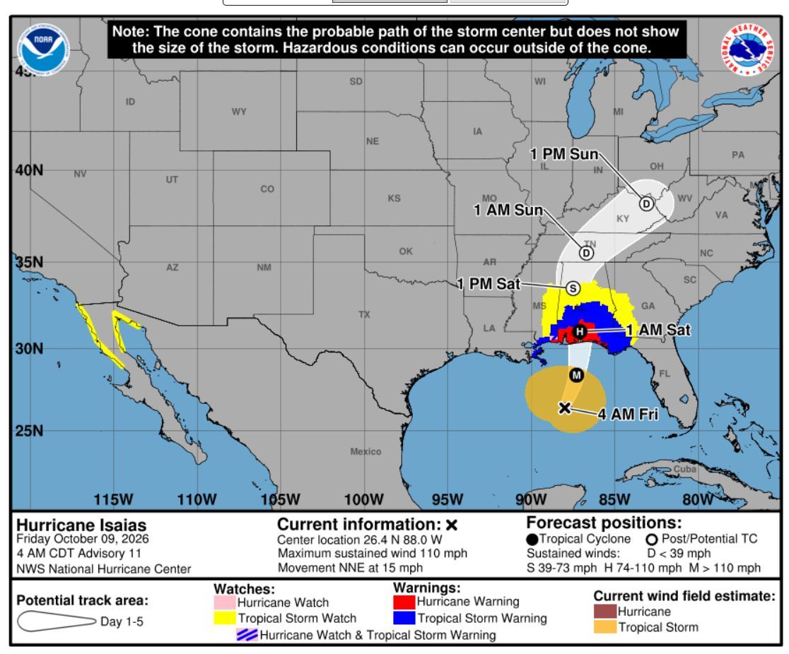
10/8/2026 – 5:00 pm EST Update
Franklin County Emergency Management has clarified that all guests and residents must depart the Island by 8:00 am EST tomorrow morning, (10/9/2026). If you need assistance, please don’t hesitate to call or text us at (850) 559-9276.
The path remains the same as it did earlier today and Franklin County remains under a Tropical Storm warning. Some folks have asked about bridge closures: All bridges will remain open until sustained winds reach 45 mph. To stay updated on wind speeds, please regularly check Weather Stem.
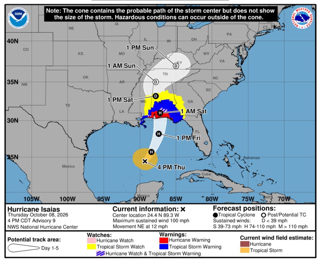
10/8/2026 – 11:50 am EST Update – IMPORTANT NOTICE – MANDATORY EVACUATION ISSUED
Out of an abundance of caution, Franklin County Emergency Management has just issued a mandatory evacuation order for barrier islands and low-lying areas, including St. George Island. The safety of our guests, owners, staff and properties are our first priority. All in-house guests are required to leave the Island no later than tomorrow morning, (Friday, 10/9/2026) and we ask that you please begin making arrangements to depart as soon as possible. Our staff is currently in the field storm-prepping our homes. If it’s possible for you to help, we ask that prior to your departure, please ensure all doors and windows are securely closed and locked, and all outside trash cans are properly secured. This can be done by putting them in an enclosed outdoor shower, or even placing them up against the home.
We sincerely apologize for the interruption to your stay and appreciate your understanding and cooperation as we work to keep everyone safe. Thank you and please travel safely.
10/8/2026 – 5:00 am EST Update
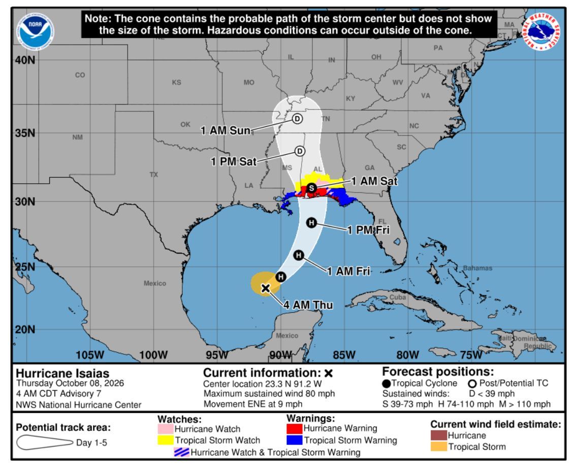
Isaias has been upgraded to a hurricane and the “cone” suggests it may make landfall somewhere between Ocean Springs, MS and the Bay/Gulf County Line. Gulf County is to the east of us and Bay/Gulf County line is in St. Joe Beach. Franklin County is not in the cone, however we are under a tropical storm warning because we may experience tropical storm-force winds ranging between 39 and 73 mph. A warning is typically issued 36 hours before the anticipated first occurrence of tropical-storm-force winds which are expected to arrive Friday. As of the 5:00 am NHC update, Isaias is expected to make landfall late Friday night/early Saturday morning and there are no evacuation orders in place for Franklin County.
10/7/2026 – 5:00 pm EST Update
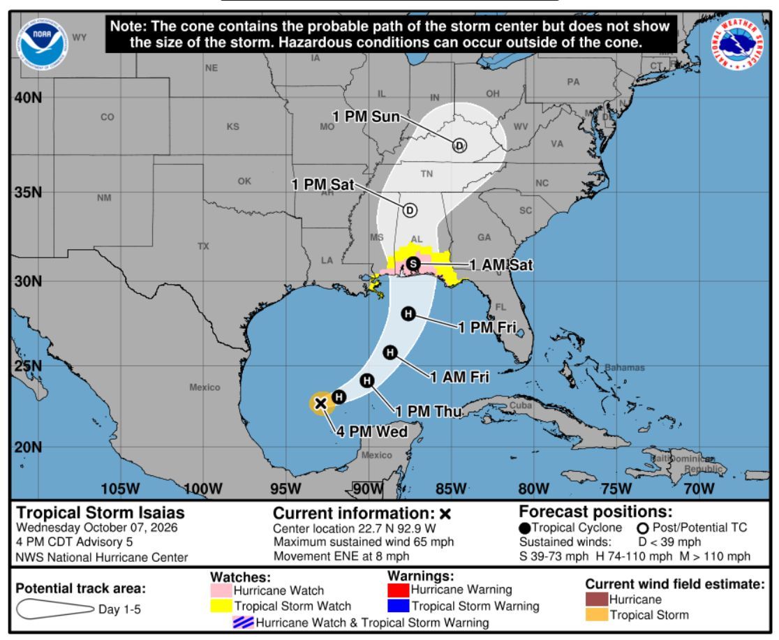
Isaias continues to strengthen – it’s now at 65 mph sustained winds. Franklin County remains under a Tropical Storm Watch and no evacuation orders have been issued. Don’t hesitate to call us if you have any questions. (850) 559-9276.
10/7/2026 – 11:00 am EST Update
The National Weather Service has issued a Tropical Storm Watch for Franklin County. At this time FCEM has not issued any voluntary evacuation orders. It’s gloomy here, but all is well.